
Along the Way
- 30” x 30”, Oil on Ampersand Gessobord
- $3500
- Prints:
Small (12″ x 12″ w/ 1″ border) $195
Medium (20″ x 20″ w 1″ border) $295
Large (30″ x 30″ w/ 2″ border) $450
Extra large (40″ x 40″ w/ 2″ border) $800
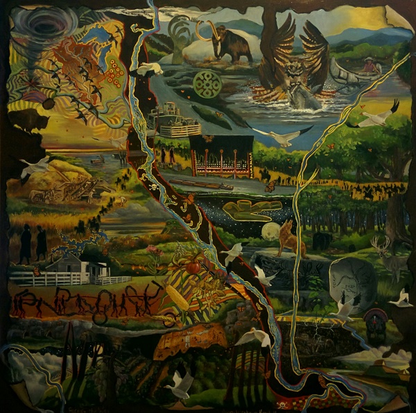
“Along the Way” reminds me of an old treasure map. Following that idea, I began researching stories (our dearest treasures) around my home area near the Mississippi River and this painting developed. In the upper left of the panel the Upper Mississippi River Valley is illustrated, including Great Lakes Superior and Michigan. The illustrated stories are rooted in the highlighted area of the map. There are the myths, legends, histories and experiences.
Images include:
- A flock of migrating Mallard ducks seen from above as they fly over the
rhythmic patterns found in farm country - The unpredictable wind demon, the tornado
- Red outlined Native American burial mounds found north of Canton, MO
- A bison overlooks a flooded plain
- The West Quincy floodplain shows a home, silo and a Spam truck, stories
from the flood of 1993 - S.H. Tuley’s steam powered thresher with crew and horses at work
- Migrating snow geese fly throughout the painting
- Migrating Monarch butterflies are found throughout the painting
- Pottawatomie Native Americans “Trail of Death” walk from IN to KS in the fall of 1838
- Sites of toxic industries
- Hannibal, MO before settlement
- Fire and prairie with Butterfly Milkweed
- Mark Twain Lake and portions of the Salt River before it merges with the Mississippi River
- Samuel Clemens birthplace, a state historical site near Mark Twain Lake
- Images of slavery. The red (out)lines indicate some current policies that restrict advancement
- The Picture Cave, on private land, the cave walls are filled with images. It was a sacred place for Native Americans who once lived here
- The Missouri River cuts across the lower left corner of the map
- Some crops raised in this region: apple, soybeans, corn, wheat, grapes
- Rhythmic patterns of cultivated land
- Trains travel along the waterways, one carrying a future energy source, fins of wind turbines
- Checkerboard pattern indicating a large city
- At the top center is an image of Mormons crossing the Mississippi River in the winter of 1838 and 1839 under threat of death from Missouri governor Lilburn Boggs
- The Copper Trail follows the Mississippi River. Native Americans created beautiful objects from the material
- Ice Age hills
- Woolly Mammoth
- Catfish is eagle’s dinner
- Birch-bark canoe and me on the water
- Old ferry boat
- Tug pushes barges up the river
- Lincoln-Douglas debate in Quincy, IL
- Pottawatomie blanket, a robe of fine dress, beautifully crafted
- Soapstone pipe, Native American
- Mama bear and cub
- Buck
- Trail through a sun dappled old-growth forest
- Coyote howls at the full moon as it rises above the river
- Native American Stone River Map
- Rock with a pictograph of a water panther from the Native American tradition
- Nettle plant with roots
- Paddle-wheeler ruins buried in the soil
- Male turkey
- Native American Mound Village. Cahokia tells a good story about this civilization.
